Sedona is a small town located two hours south of the Grand Canyon. Coconino National Forest surrounds Sedona and provides numerous recreational activities including biking, fishing, camping, horse riding, and hiking. Hiking is my all-time favorite hobby. I prefer intermediate trails but I do recommend hitting some of the easier, more popular trails for the iconic Sedona views.
Before you hike…
Before I dive into my hiking recommendations, I want to talk about the weather. Sedona does experience snow at the higher elevations. Keep this in mind if you want to hike in the winter months. In the summer, the temperature hits 100F (or 36C) by the afternoon so I only hike in the mornings or evenings during this time of the year. Bring more water than you think you need and wear a hat.
I’d also like to mention the presence of wildlife. I’ve seen several coyotes on my hikes but they’re usually skittish. In the evening, I’ve noticed snakes and hares about. I can’t stand snakes so I usually wait for them to move. As a general reminder, don’t feed the wildlife or leave food on the trails for them.
Lastly, stay on the trail. Many unofficial hiking destinations have garnered viral social media attention. Going off trail accelerates damage to the ecosystem (this includes plants, soil, and animals). There are obvious signs posted at these areas to discourage hikers from “accidentally” wandering there.
I’ve drawn out all my favorite trails listed above on Google Maps. This makes it easier to see the proximity of the trails. Many trails interconnect so the loops I recommend are suggestions.
The must-see trails
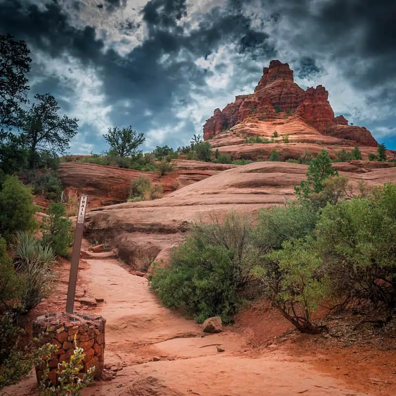
Bell Rock is one of the most recognizable Sedona landmarks. There are two trail options I recommend to get a view of this. First is the Courthouse Butte Loop, which takes you directly to Bell Rock and you can wander around its base. Located across the highway is the Slim Shady-Made in the Shade Loop. This loop has less foot traffic and gives you a view of Bell Rock. Both trails are accessible from the Bell Rock parking lot but it’s not necessary to do both trails.
Airport View Trail is best at sunset. This is a popular area with a small and a large parking lot. There is an option to do the 3.2 mile loop around the Airport Mesa. Usually by the evening, my energy is spent so I prefer taking a short walk instead of doing the full loop. I recommend paying to park in the large lot, walking down the Airport View trail, and sitting on top of the red rock to watch the sunset. However, if you have trouble seeing at night, don’t take the Airport View trail because there are no street lights to guide your way after the sun sets.
Cathedral Rock and Chapel of the Holy Cross are often mentioned as the best trails for first time visitors. Personally, I find the views are better on other trails. Cathedral Rock has a frequently instagrammed spot if you climb high enough. Chapel of the Holy Cross is a small, one-room building with limited parking.
Devil’s Bridge is also another well-known trail and is extremely crowded. If it’s too packed for you, Vultee Arch Trail is a great alternative to see a natural bridge. And if you want to see a cool man-made bridge, drive out to the Midgley Bridge.
| Trail Name | Distance (approximate miles) | Elevation gain (approximate feet) |
| Courthouse Butte Loop | 4 | 360 |
| Slim Shady – Made in the Shade Loop | 2.3 | 350 |
| Airport View Trail | 1.4 | 240 |
My favorite hikes so far
The Soldier’s Pass – Brins Mesa – Jordan Loop is where I fell in love with Sedona. This trail took me through various terrains and showed me the diversity of desert. I came across two frequently photographed Sedona landmarks on this trail: Seven sacred pools and the Devil’s Sinkhole. Both were smaller than I expected but still great to check those off my bucket list.
Fay Canyon is good for families and solo hikers. To make the hike shorter, I skip the Fay Canyon Arch side trail. I’ve been to the Arches National Park in Utah recently so I felt like I could move past this one. Fay Canyon is beginner level at first but then the trail leads you to a red rock mesa. The trail gets steep and narrow here; I did see some families with small children hesitate to continue at this point. I end my hike where there’s a rock overhang and several people are sitting to enjoy the view. The trail continues deeper into the canyon but I couldn’t tell where it ends.
Mezcal to Boynton Pass has spectacular views that can be enjoyed by hikers and mountain bikers. Rounding the trail on Mecal Mountain and seeing the Boynton Canyon took my breath away the first time I saw it. There is an option to do a 4.4 mile loop by skipping the turnoff to Boynton Pass and continuing on Mezcal to Deadman’s Pass then to Long Canyon Trail. I hiked the loop on my first visit but decided going to Boynton Pass was more enjoyable. Either option works!
| Trail Name | Distance (approximate miles) | Elevation gain (approximate feet) |
| Soldier’s Pass – Brins Mesa – Jordan Loop | 5 | 830 |
| Fay Canyon and Fay Canyon Arch Trail | 2.6 | 380 |
| Mezcal – Boynton Pass Trail | 5.5 | 500 |
Notable intermediate/advanced hikes
Further down the road from Fay Canyon is the Bear Mountain Trail. I go here if I want a workout. The elevation change here hits me. There’s minimal shade on this trail so I recommend starting early on this hike.
These three trails I haven’t been to yet, but they are on my list and were recommended to me by others. Wilson Mountain can be started from the aforementioned Migdley Bridge, so you can hit two birds with one stone here. Secret Canyon is a difficult trail to follow since it’s washed out and keep in mind the driving here is tough. West Fork Trail is in the intermediate section because of the distance, though the trail itself is easy.
| Trail Name | Distance (approximate miles) | Elevation gain (approximate feet) |
| Bear Mountain | 4.9 | 1,975 |
| Wilson Mountain | 11.5 | 2,805 |
| Secret Canyon | 8.8 | 790 |
| West Fork Trail | 7.2 | 820 |